One year ago today: June 5, 2022, The Bamboo, now $1150
Five years ago today: June 5, 2018, feeling discouraged.
Nine years ago today: June 5, 2014, plastic razor.
Random years ago today: June 5, 2012, pushy sellers.
Leaving Hermitage at 8:00AM for Florida, it’s a day of good news and not so good. When my auto insurance goes up $110, according to them that is not a massive price hike, it is a general rate increase. I’m paid up until December.

Making good time, I turned into the woods at Soddy-Daisy but did not really catch sight of the Tennessee River. It is really an artificial lake. I got turned around looking for the Fairview bridge and wound up driving through north Chattanooga, a wasted hour, really. Doubling back, I got on a better route to a nothing town called Prospect, then on to an even more nothing town called Cleveland.
Where I wound up offending two fat ladies. Hey, it is not my fault libraries and museums hire 85% fat old ladies. I figure it is because chickenshit management are too wimpy to enforce their own idiotic policies, so they hire grandmothers to do the work for them. As I walked through the lobby, the fat ladies called out. Today the museum was “not open to the public”. All I said is I must have missed their sign to that effect out at the entrance gate, because I had pulled off the highway, drove all the way down their driveway, parked, and walked in, all within the last ten minutes. Offended. They are there to run a museum, not put up signs for other people to read.
When the DeLorme (topographical map) says unimproved road, they mean it. I had to double back to find the entrance to Road 302. The DeLorme calls it FR 302 (frontage road) and the GPS says NR 302 (national park). Neither are accurate, it is locally called by two names, Indian Creek Road and Jake’s Trail. This misleading map shows the route along the south edge of the lake, but in reality, the entire right side of the map is either off limits, a private bible camp, or simply blocked off at the upper reaches in the case of Jake’s trail.

The trip was more adventure than I’d recommend for the casual driver and really should have required more safety and survival gear than I was carrying. You done been told. The condition of the trail, while drivable, is not passable to cars. Time and distance became meaningless after the first half-hour, in the end it required 4-1/2 hours to travel an estimated 23 miles, the worst part being the last. At the end of 302, 11 miles in, I met a sign saying no trespassing. Rather than take the same return route, I found side trail with a tiny sign saying “Baker”. Most people would have rated this a mistake. It was the final leg, taking 3 of the hours to descend from 1401 feet to 783 feet, all in low gear and burning up 2/3 of a tank of gas.
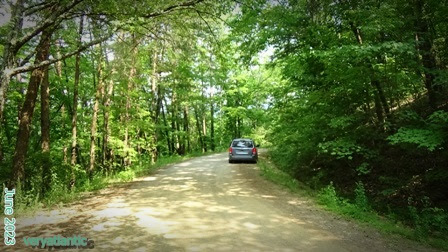
Despite the higher altitude, it was a muggy hot day, the sort of thing I supposed the Cherokee must have liked. There were none to ask, nobody lives there in those thousands of acres of land. Call it First Nations, Great Nations, whatever, there is no evidence that anybody had ever been there. But if anyone claims the place to get back to their old ways, this would be an excellent place to start. This view shows the van parked on a typical section of the best road, I met two trucks coming down the mountain from the bible camp, both speeding. The claim is these aboriginals build a great nation but I can guarantee you no Indian tribe of any size or description built that road.
Wal*Mart™ electric guitar kit.
Remember to use BACK ARROW to return to blog.
The road is only open to around the jog on the penninsula I’m pointing at, the markings down the valley on the right are not accessible, though several spot show clearly enough there may once have been a way in by off-road vehicles. Most of the road is a sheer drop on the lake side. It’s green with only two species of flower making a show. This orange flower was most prevalent, always in small clearing on the sunny side of the embankments. On the ascent, there are one or two spots maximum where you can glimpse the lake. The northern shore must be developed due to the number of noisy motorboats that could be heard even from the most distant heights.

The trail I took had not been touched in at least five years. I was able to straddle the pot holes and tire ruts and still regularly scraped bottom. I have gear enough to overnight or more and stay healthy but a ruptured tank or broken axle would mean a day’s hike through the mosquitoes and guessing which fork to take at two or three places. The heat and mugginess stayed the whole time, no refreshing breezes. Where logs had fallen over the road, they were neatly chain-sawed clean. But water had carved small gulleys across the path and where steep enough, along it for often 100 feet at a time.

Here is a video clip taken by the dashcam., recall what I just said about the conditions. This is also misleading but conveys some of the dangers. First, this video is about twice the speed you would dare move on these trails. Second the bug-splattered windscreen and optics means you can’t clearly see the size of the ruts and potholes. Most are more than axle-deep, fall in them by driving anywhere but the crest and you are high-centered. And I have no winch.
There is also a certain amount of deadfall along the mountain side of the cut. On the side trails, these have been nudged out of the way by passing vehicles, of which there were none today. No humans in evidence until I got way, way down the mountainside and emerged on a track called “Peabody Sween” according to DeLorme, but unmarked. They were campers, if you want to call it that, more like techno-camping. You know, a four-room tent with a satellite dish.
One kid I did envy though. He was way up the mountain with his tent on a finger of land approachable from one path only. All kinds of excellent camping gear and a late-model 4x4 parked a mile away. At that age, I was doing back-breaking labor on a muck farm, empty, meaningless toil for which I never got paid. And here is this kid in the Tennessee mountains with his girlfriend and I am not going to be the one to tell you her age.
ADDENDUM

Here’s a carved Indian head outside the closed museum. The photo is not skewed, it is really that long, narrow shape. Kind of like symbolism when reality isn’t good enough. Thank DeLorme for this trip, as this could not have been done with GPS. “Proceed to highlighted route” does not cut it from the middle of the Cherokee National Forest, Tyler-boy. Mind you, any budding navigators can find me at Lat N 35° 04.8182’ and Lon W84° 35.0537’

Some time later, I came across a set of tire tracks with a surprisingly narrow tread. That’s the first evidence anyone had been this way in at least a year. There were bare rocks showing on the road bed, so I guessed that vehicle had limited clearance. By leaning out the window, I was able to follow the same path, kind of half-expecting I’d find an abandoned go-kart type of rig. This made the road slightly safer knowing somebody had made it, but also a lot slower and by now there were some growing shadows.
Finally, near a place called Willis Springs, I encountered creek crossing on the road. They had been lined with paving stones to let the water over the trail. The bank angle was enough to cause me worry but there was no turning back. I had to wade the KIA over both creeks, each time scraping the front and rear bumpers on the grade. I emerged intact near this battered sign, the first indication I had found Sylco. Not far back up the way I came is a beautiful waterfall. I’ll see if I can find the footage, this might be the water part of Willis Springs.

Overall, this was great fun but that is subject to interpretation. Parts were dangerous but not seriously risky. I wrongly took the map to mean unimproved roads similar to Florida and the Tennessee version was worse. The road has 220 turns, somewhat equal in parts of hairpin, right angle, and swing the steering wheel. (The counter is carried inside the KIA for such opportunities.) Gas consumption doubles on the uphill parts. A reminder there are no water sources, and even the insects that don’t bite get on your c
The trip was worth it, but more for the campers than sightseers. I got out to stretch regularly and check the undercarriage. Everything on the KIA seems well protected or recessed back into the floorboards, so that was okay. I’m used to cold in these circumstances but this time had to run the A/C full maximum the entire time. You can really fell it tug on the motor and the amount of condensation under the vehicle is enough to puddle, causing some trepidation. Pack a lunch, when you descend into the nearby valley, the roads all go southwest across the Georgia line and after 6-ish, you’ll have to find a food mart of gas station for any refreshments.
